Hurricane Ian caused extensive damage in Florida last night. A tidal wave 3.6 meters high caused major flooding and two million homes were left without electricity. As far as is known, there have been no fatalities on the mainland. This is due to timely warnings and evacuations of 2.5 million people. In fact, the American KNMI already warned in May to be very prepared. How would the weather service know?
Almost all Americans know when to expect potential hurricanes: in summer and fall. In the United States they call this period hurricane season, hurricane season. This officially runs from June to November, but the strongest storms usually come in September and October.
One hurricane season is not like another. Some years it’s quiet for months, while other years hurricanes come and go like airplanes approaching a runway. Americans can predict well in advance whether this will be a calm, moderate, or extremely dangerous hurricane season. “Be prepared and know your risks,” the US KNMI (NOAA) said in May, predicting an above-average strong hurricane season.
In the following months, according to the climate institute, a total of 14 to 21 major storms would follow. Six to ten of these storms would become hurricanes, of which three to six would become severe hurricanes. Hurricanes are violent from category 3.
By the time Ian made landfall in Florida overnight Wednesday-Thursday, he had nearly reached hurricane force 5 – a heavy maverick.
The key to hurricane prediction lies in the Pacific Ocean
By monitoring both the skies and the oceans, NOAA can make fairly reliable predictions.
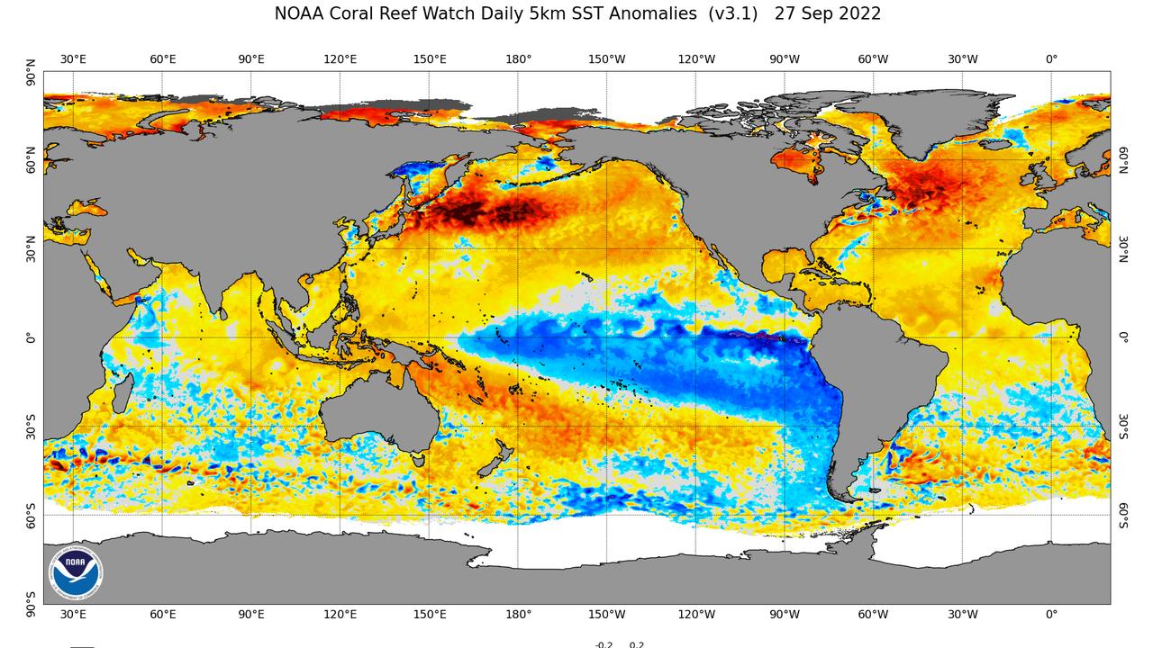
American hurricanes originate in the Atlantic Ocean. But the strength of the hurricane season is determined in the Pacific Ocean, west of the United States. There will be very strong trade winds this year. They blow warm tropical water towards Indonesia and Australia. At the same time, cold water is gushing off the US West Coast from the great depths of the ocean. This weather phenomenon is called La Niña and can be recognized by the blue corner on the map below.
Blue water is relatively cold, yellow and red water is warmer than normal.

Blue water is relatively cold, yellow and red water is warmer than normal.
Photo: NOAA
West winds blow over hurricanes
Cold waters off the west coast of the United States attenuate westerly winds at high altitudes. If these westerly winds are strong, they can blow over the top of a hurricane or tropical storm. The storm can then no longer grow, collapses and becomes harmless.
For example, the United States always has a more turbulent hurricane season during La Niña. And it can be planned months in advance. The opposite situation occurs during El Niño. The United States generally has a calmer hurricane season.
Hurricane forecasts can also be based on this in Asia. There, the relationship is reversed: when the United States has to endure one hurricane after another, the Philippines is generally calmer than usual.
More frequent dropouts due to climate change
Finally, there is climate change. This will not lead to an increase in the number of hurricanes, but will lead to an increase in hurricane strength. Hurricanes also bring more rain due to climate change.
Additionally, warming oceans may cause hurricanes to move more often into areas that were previously untouched. An example of this is Hurricane Sandy which hit New York in 2012.

“Infuriatingly humble social media ninja. Devoted travel junkie. Student. Avid internet lover.”
 DodoFinance Breaking News Made For You!